Geography and a practical first visit
Compare two lakes.
See where they are, how their landscapes differ, and what it takes to reach a named place on each lake.
Country & region filters All places
Choose two different lakes.
Choose two lakes to begin.
At a glance
Lake Tahoe has about 344 times the recorded surface area of Lake Bled. Lake Tahoe has the greater recorded maximum depth.
Access below compares Sand Harbor — Sand Point Nature Trail with Bled lakeside promenade to Velika Zaka. It does not rate the difficulty of either whole lake.
| Overview | Lake Tahoe | Lake Bled |
|---|---|---|
| Lake type | Lake Tahoe Natural lake; regulated outlet | Lake Bled Natural lake |
| What to expect | Lake Tahoe A window into the Sierra | Lake Bled Small lake, unmistakable island |
| Read the full article | Lake TahoeLake Tahoe guide & sources | Lake BledLake Bled guide & sources |
Location and maps
| Location | Lake Tahoe | Lake Bled |
|---|---|---|
| Country / countries | Lake Tahoe United States | Lake Bled Slovenia |
| State, province or equivalent | Lake Tahoe California, Nevada · United States | Lake Bled Municipality of Bled · Slovenia |
| Geographic region | Lake Tahoe Sierra Nevada | Lake Bled Julian Alps foothills, northwestern Slovenia |
| Gateway towns | Lake Tahoe
| Lake Bled
|
Each map fits its own lake extent and may use a different scale. Equal-sized panels do not mean equally sized lakes. Compare area and depth in Lake facts.
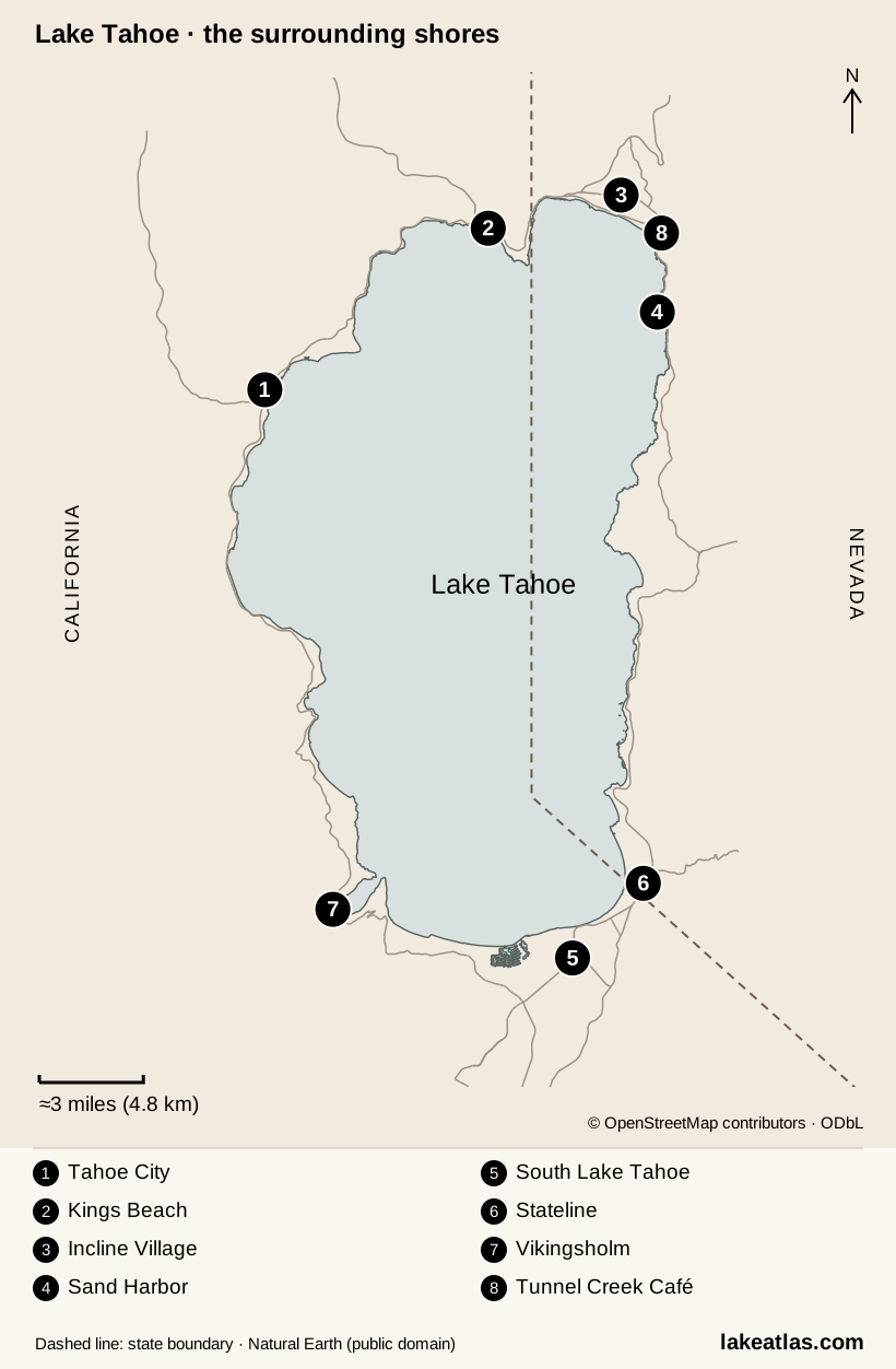
Exact access-point coordinates are not verified; no marker has been guessed.
- 1Tahoe City · Truckee River outlet
- 2Kings Beach
- 3Incline Village
- 4Sand Harbor
- 5South Lake Tahoe
- 6Stateline
- 7Vikingsholm · Emerald Bay
- 8Tunnel Creek Café · near the trail’s northern end
Map scale & attribution
Local location map of the Tahoe basin. Thin lines show selected main roads from OpenStreetMap, not a recommended driving route. Numbered places and the distance scale show how spread out the shores are. The dashed line is the California–Nevada boundary.
Map design: LakeAtlas. © OpenStreetMap contributors, ODbL, retrieved October 8, 2026. State boundary: Natural Earth, public domain, retrieved October 9, 2026. Source GeoJSON.
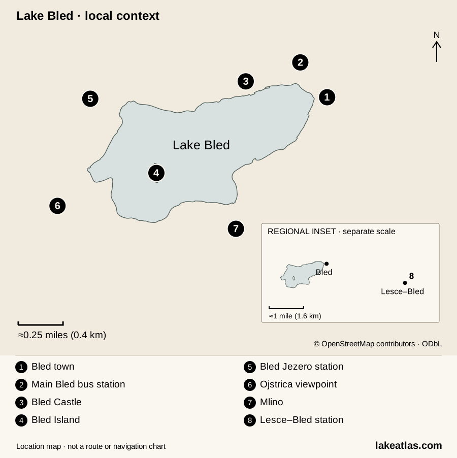
Exact access-point coordinates are not verified; no marker has been guessed.
- 1Bled town · eastern shore
- 2Main Bled bus station
- 3Bled Castle
- 4Bled Island
- 5Bled Jezero station
- 6Ojstrica viewpoint
- 7Mlino · south shore
- 8Lesce–Bled station · regional inset
Map scale & attribution
Local location map with a separate regional inset. Lake outline and selected places use source geometry; numbered symbols identify places, not an itinerary. No walking route is drawn.
Map design: LakeAtlas. undefined Source GeoJSON.
Lake coordinates
Lake Tahoe: 39.10000, -120.03000 (latitude, longitude). Lake locator only; not a driving destination.
Lake Bled: 46.36880, 14.11397 (latitude, longitude). Lake locator only; not a driving destination.
Getting there and physical effort
These are destination-specific descriptions. “Not verified” means we have not established that feature; it does not mean access is impossible.
| Access detail | Lake Tahoe | Lake Bled |
|---|---|---|
| Named destination | Lake Tahoe Sand Harbor — Sand Point Nature Trail Shoreline and beach | Lake Bled Bled lakeside promenade to Velika Zaka Shoreline path |
| Getting there | Lake Tahoe Car · Walking · Bicycle Drive to the Sand Harbor park entrance on Highway 28, or approach via the paved East Shore Trail from Incline Village. | Lake Bled Walking · Public transit/shuttle Arrive at Bled’s main bus station and continue to the lake promenade. This entry covers the north-shore paved section toward Velika Zaka. |
| Effort from this access point | Lake Tahoe Short walk Sand Point Nature Trail is 0.33 miles (0.5 km) in total; Nevada State Parks identifies it as accessible. | Lake Bled Not verified Paved waterfront section; an end-to-end distance for this exact accessible segment is not verified. |
| Mobility accessibility | Lake Tahoe Accessible nature trail and paved picnic-area paths; this does not establish step-free access across beach sand. | Lake Bled Bled Tourism identifies the asphalt route from central Bled beneath the castle to Velika Zaka as wheelchair suitable. The following unpaved section is not. |
| Planning requirements | Lake Tahoe
| Lake Bled
|
| Official directions & access | Lake TahoeOfficial visitor information for Sand Harbor — Sand Point Nature Trail | Lake BledOfficial visitor information for Bled lakeside promenade to Velika Zaka |
Lake facts
| Measurement | Lake Tahoe | Lake Bled |
|---|---|---|
| Surface area | Lake Tahoe191 sq mi (495 km²) Lake surface; not watershed area. | Lake Bled0.56 sq mi (1.44 km²) Lake surface; not watershed area. |
| Maximum depth | Lake Tahoe1,645 ft (501 m) Deepest recorded point; not average depth. | Lake Bled100 ft (30.6 m) Deepest recorded point; not average depth. |
| Lake elevation | Lake Tahoe6,225 ft (1,897 m) Source reference elevation; see measurement notes. | Lake Bled1,558 ft (475 m) Source reference elevation; see measurement notes. |
| Water classification | Lake Tahoe Freshwater | Lake Bled Freshwater |
Measurement definitions & source notes
Area is the water surface, not volume. Maximum depth is not an average. Separate zero-based linear scales compare this pair; reference or full-pool values are not live reservoir readings.
Lake Tahoe
Rounded UC Davis figures: area about 191 sq mi (495 km²), maximum depth 1,645 ft (501 m). Mean surface elevation is about 6,225 ft (1,897 m). EPA instead rounds area to 192 sq mi (497 km²); its natural-rim elevation is a different definition. Comparisons consistently use the UC Davis figures.
Article measurements reviewed 2026-10-09
Article measurement sourcesLake Bled
Area follows Bled Tourism’s 0.56 sq mi (1.44 km²), published as 356 acres (144 ha). Maximum depth is 100 ft (30.6 m), not mean depth. The circuit of approximately 3.7 miles (6 km) is a visitor walking route, not a surveyed shoreline measurement.
Article measurements reviewed 2026-10-09
Article measurement sourcesVisiting and activities
| Visit detail | Lake Tahoe | Lake Bled |
|---|---|---|
| Seasons | Lake Tahoe Summer supports beach visits and paddling, with busy parking and seasonal reservations. Snow affects mountain access in winter. Confirm the chosen park’s access and forecast; lake water remains cold even when the shore feels warm. | Lake Bled The Castle Bathing Area normally welcomes swimmers from June to mid-September. The lake promenade supports visits beyond bathing season; winter conditions and individual attraction opening hours require a separate check. |
| Activities at named places | Lake Tahoe Walk Sand Point Nature Trail at Sand Harbor, cycle the East Shore Trail, or descend to Vikingsholm at Emerald Bay. Paddling rentals operate seasonally at Sand Harbor; choose an activity around the specific shore access. | Lake Bled Walk the paved north-shore promenade, swim at the managed Castle Bathing Area in season, or take a pletna to Bled Island. Island steps and boat transfers impose different mobility demands from the promenade. |
| Towns & services | Lake Tahoe Sand Harbor has picnic areas and seasonal paddling rentals. Tahoe’s shore communities offer lodging and meals; Emerald Bay’s steep shore access needs more advance planning. | Lake Bled Bled provides accommodation and restaurants. The lido has showers, changing facilities and cafés; accessible public toilets are listed at specific waterfront locations. |
Access and visiting information checked 2026-10-09. Researched guidance, not firsthand reporting. Check the official destination before travel.
Sources & access notesOfficial destinations, transport and land managers
Lake Tahoe
- UC Davis — Tahoe factsRounded dimensions, elevation and Truckee River outlet · Checked 2026-10-09
- USGS — Lake Tahoe basinTectonic basin formation during Sierra Nevada uplift · Checked 2026-10-09
- California State Parks — Geological GemsGlacial shaping of Emerald Bay · Checked 2026-10-09
- NASA JPL — Tahoe site descriptionLake heat storage and winter behaviour · Checked 2026-10-09
- UC Davis — 2025 clarity report2025 annual Secchi mean, published June 2026 · Checked 2026-10-09
- UC Davis — State of the LakeClimate, mixing and ecological pressures · Checked 2026-10-09
- Tahoe City PUD — Commons BeachPublic lakefront park and facilities · Checked 2026-10-09
- California State Parks — Kings BeachBeach facilities and dog restrictions · Checked 2026-10-09
- IVGID — Incline Village beachesRestricted beach entry · Checked 2026-10-09
- City of South Lake Tahoe — visitorsSouth-shore visitor context · Checked 2026-10-09
- Tahoe Fund — East Shore TrailThree-mile paved shared-use trail · Checked 2026-10-09
- Tahoe Fund — trail descriptionTrail alignment and exposed sections · Checked 2026-10-09
- California State Parks — Emerald BayVikingsholm descent, access restrictions and 2026 tour closure · Checked 2026-10-09
- UC Davis — Tahoe Science CenterIncline Village location and timed-tour booking · Checked 2026-10-09
- US Forest Service — Tahoe recreationSeasonal facilities and snow-dependent opening · Checked 2026-10-09
- UC Davis — air quality and UVCurrent local atmospheric observations · Checked 2026-10-09
- Caltrans — chain controlsWinter road restrictions and vehicle requirements · Checked 2026-10-09
- Reno–Tahoe Airport — ground transportAirport shuttle operators · Checked 2026-10-09
- North Lake Tahoe ExpressScheduled airport service; advance reservation · Checked 2026-10-09
- South Tahoe Airporter — FAQSouth-shore stops and reservation planning · Checked 2026-10-09
- TART — MainlineTahoma–Incline Village transit corridor · Checked 2026-10-09
- Lake Link — service areaOn-demand south-shore transit within a defined zone · Checked 2026-10-09
- Tahoe Transportation District — 2026 summer serviceEast Shore Express ended 12 September 2026 · Checked 2026-10-09
- Nevada State Parks — Sand Harbor reservation FAQSeasonal vehicle reservations and pedestrian entry · Checked 2026-10-09
- Nevada State Parks — reservationsSeasonal reservations and official booking action · Checked 2026-10-09
- Nevada State Parks — Sand HarborPark entry, pedestrian access and restrictions · Checked 2026-10-09
- North Lake Tahoe Fire Protection District — water safetyCold-water and wind hazards · Checked 2026-10-09
- Tahoe Boat Inspections — FAQWatercraft inspections and clean, drain, dry guidance · Checked 2026-10-09
- US EPA — About Lake TahoeWashoe context; alternate area and natural-rim elevation figures · Checked 2026-10-09
- TART — Highway 89Tahoe City–Truckee transit corridor · Checked 2026-10-09
- California State Parks — Emerald Bay accessible featuresSteep Vikingsholm approach, accessible parking and limited shore facilities · Checked 2026-10-09
Full article bibliography and measurement notes
Lake Bled
- Bled Tourist Board, About BledPublished area, depth, elevation and lake dimensions · Checked 2026-10-09
- Bled Tourist Board, Accessible tourismPaved waterfront section and surface limitations · Checked 2026-10-09
- Bled Tourist Board, By busBus arrival and main station · Checked 2026-10-09
- Bled Tourist Board, By trainLesce–Bled versus Bled Jezero stations · Checked 2026-10-09
- Bled Tourist Board, Swimming and bathingDesignated bathing areas · Checked 2026-10-09
- Bled Tourist Board, Pletna boatTraditional pletna boats and boarding places · Checked 2026-10-09
- Castle Bathing Area operator — facilitiesNamed address, bathing facilities, accessible toilet and water access · Checked 2026-10-09
- Bled Tourism — Lake BledNatural postglacial lake formation · Checked 2026-10-09
- Bled Tourism — OjstricaNamed forest approach from Velika Zaka; short but steep ascent and published time · Checked 2026-10-09