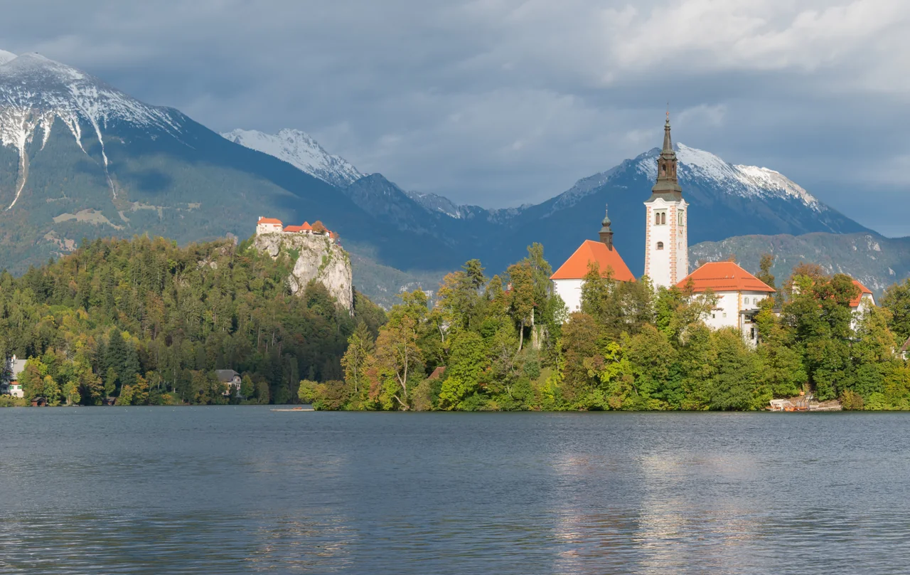

Where Lake Bled is and how it formed
Bled lies in Slovenia’s Alpine northwest, where mountain scenery meets a settled town waterfront. The lake is about 1.32 miles (2.12 km) long and up to 0.86 miles (1.38 km) wide. These dimensions measure across the water; the walking circuit follows the shore and is longer.
The tourism board gives a surface area of 0.56 sq mi (1.44 km²) and a maximum depth of 100 ft (30.6 m). Surface area measures the lake’s footprint, not the amount of water it holds. Maximum depth is the deepest point, not the depth throughout the lake. Bled’s compact size makes a shoreline walk practical without making its steep viewpoints part of the same easy outing.
Its basin began as a tectonic depression and was reshaped by the Bohinj glacier. Water occupied the hollow after the ice retreated; the island is a resistant remnant of the landscape. The familiar scene therefore owes its form to both movements of the earth and glacial erosion.
Springs supply the lake, but it has no large natural tributary. Limited water exchange makes nutrient inputs important. Bled’s recovery from past enrichment involved an artificial inflow from the Radovna in 1964, a deep-water siphon in 1980–81, and improvements to sewage collection. The present lake reflects decades of active restoration as well as its glacial history.
Phosphorus can promote algal growth and reduce transparency. Slovenia’s environment agency reports an annual average of 42 µg/US gal (11 µg/L) of phosphorus for 2024, in an indicator updated in November 2025. That is ecological monitoring, not a statement about whether a bathing area is suitable today.
Finding your way around Lake Bled
Match the numbered places to the list below. Open the full-size map for labels and detail.
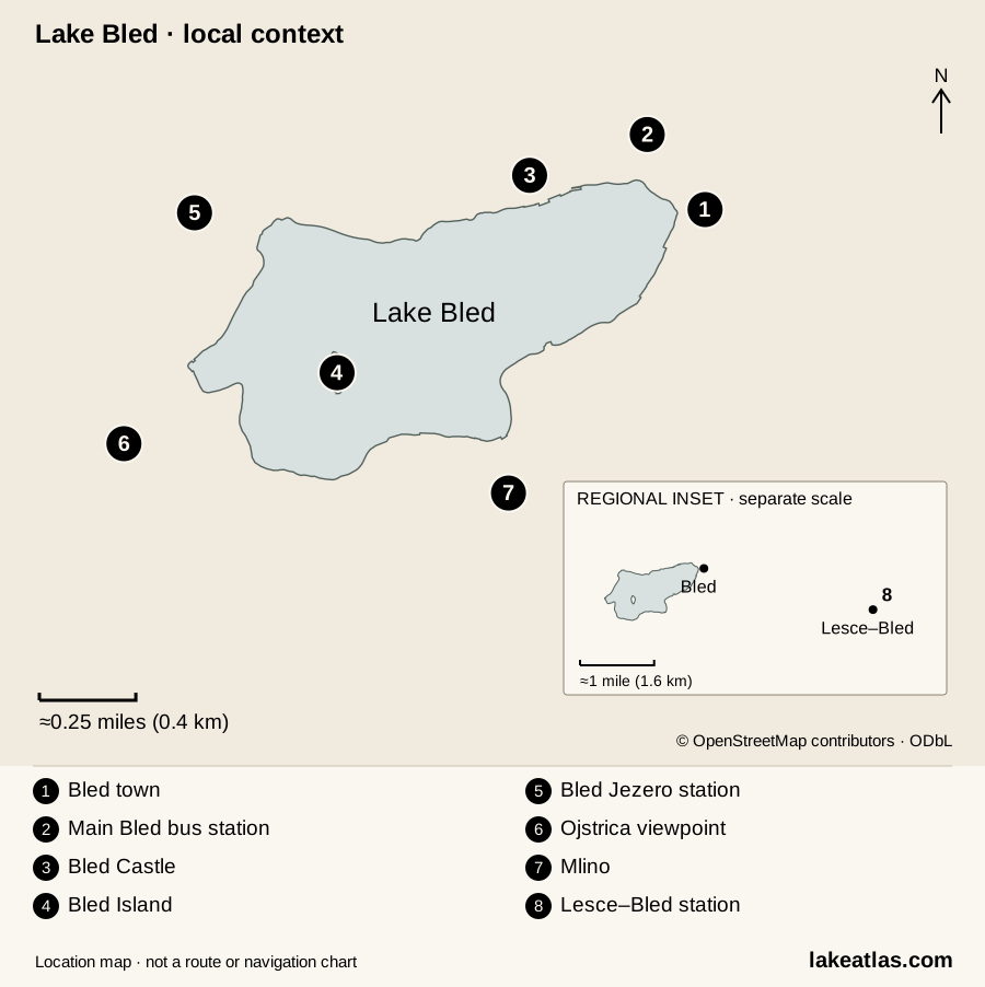
- 1Bled town · eastern shore
- 2Main Bled bus station
- 3Bled Castle
- 4Bled Island
- 5Bled Jezero station
- 6Ojstrica viewpoint
- 7Mlino · south shore
- 8Lesce–Bled station · regional inset
Map design: LakeAtlas. © OpenStreetMap contributors, ODbL. Selected data retrieved October 8, 2026. Map data (GeoJSON).
Places around Lake Bled
| Place | What to expect |
|---|---|
| Town / eastern shore | Promenade, visitor services and the main bus station nearby. A convenient arrival point for a visit on foot. |
| Castle / northern shore | The castle rises above the lake; Grajsko kopališče is a managed lido below. Visiting the castle requires an uphill approach. |
| Mala Zaka / northwest | Rowing activity and designated lake access, near Bled Jezero station. Give rowing operations room. |
| Velika Zaka / west | Bathing area, campsite and the approach to western viewpoint trails. The hill climbs are separate from the lakeside walk. |
| Mlino / south | A traditional pletna boarding area. A useful place to arrange an island visit and agree the return. |
| Bled Island | Church, bell tower and historic buildings reached by boat. The southern stair has 99 steps; paths on the island also climb. |
The shore path, the island crossing and the western viewpoints answer different needs. You can understand the lake from the promenade without climbing, while Ojstrica requires a steep forest ascent and an island visit requires an authorized boat arrangement. Treat them as separate choices when planning time and mobility needs.
Things to do at Lake Bled
Walk the lakeside circuit
The tourism board describes a circuit of about 3.7 miles (6 km), with about 90 minutes of walking before longer stops. It includes paved and unpaved surfaces. The paved section from town beneath the castle toward Velika Zaka offers a shorter out-and-back option; do not assume that the whole circuit has the same surface or mobility requirements.
Take a pletna to Bled Island
A pletna is a wooden passenger boat propelled by a standing oarsman. Mlino and Velika Zaka are established boarding places; the tourism board’s current dock list also includes Kazina and Vila Bled. Authorized passenger services and traditional wooden rowing boats provide other island access. Confirm the return arrangement and admission to the church or tower before boarding: a crossing and a visit to the island’s attractions are separate purchases or arrangements.
Climb Ojstrica or visit Bled Castle
Ojstrica stands about 2,005 ft (611 m) above sea level. Its short forest approach from the Velika Zaka side is steep; the published estimate of about 20 minutes is for the ascent, not the entire outing. Allow for the descent and use footwear suited to the path. Wet or icy ground changes the decision.
Bled Castle adds courtyards, a museum, chapel and printing works to the panorama. Even the approach from the castle parking lot is steep and can be slippery. If that climb poses a problem, ask the operator about your specific needs before booking.
Best time to visit Lake Bled
Summer offers the broadest choice of water activities and seasonal transport. Spring and fall suit a visit centered on walking, the island, and the castle, provided the services you need are operating. Winter can suit a shorter town-and-lakefront stay, with more attention to snow, ice, and daylight. Choose the season around the visit you want rather than expecting the same activities all year.
Lake Bled by season
| Season | Conditions and activities |
|---|---|
| Spring | A visit centered on the shore, town and cultural sights. Summer transport and bathing facilities should not be assumed to be operating. |
| Summer | The widest range of water activities and seasonal visitor transport, alongside pressure on roads and parking. Plan your arrival and allow for changes in weather. |
| Fall | Shore walks and changing foliage, with shorter days and fewer summer services. Check the return journey before leaving your base. |
| Winter | A different mountain setting for a town-and-castle visit. Snow, ice or fog may affect paths and views; a frozen-looking lake is not evidence of safe ice. |
As checked October 9, 2026, the advertised Bled Bus season ended on September 30. Check the operator’s next published schedule before planning around this seasonal service.
Getting to Lake Bled and around the lake
Buses connect Ljubljana and Bled, with arrivals at the main station near the northeastern waterfront. Ljubljana Airport is about 22.4 miles (36 km) from Bled; the tourism board lists a direct bus option as well as connections through Ljubljana. Check the actual date and stop names in the operator’s planner rather than relying on an old frequency claim.
Bled’s two train stations
| Station | Location and onward travel |
|---|---|
| Lesce–Bled | On the main railway line, about 2.5 miles (4 km) from central Bled. Plan an onward bus, taxi or walk; this is not a lakeside station. |
| Bled Jezero | Above the western shore, on the Jesenice–Nova Gorica line. The 2026 mobility map gives walking routes of 1,969 ft (600 m) to Mala Zaka, 0.81 miles (1.3 km) to Velika Zaka and 1.6 miles (2.5 km) to the main Bled bus station. |
A car is not essential for a lake-centered visit if your arrival and return connections work. It is more useful for accommodation away from transit or a wider regional trip. Once here, use a designated parking lot and explore on foot; rates and conditions vary by location.
Swimming, boating, and shore access
Designated bathing areas include Mala Zaka, Velika Zaka, Grajsko kopališče, and the bathing areas at Grand Hotel Toplice and Vila Bled. Hotel areas and the managed lido have their own admission arrangements. Check the official bathing-water information and local notices before entering the water; a lake-wide ecological measurement cannot establish conditions at a particular beach.
For your own kayak, canoe or paddleboard, the municipal guidance identifies Mala and Velika Zaka as entry and exit points. Those recreational craft may not land on Bled Island. Island access is reserved for the specified authorized craft and landing places; powered recreational boards and e-foils are prohibited.
Stay on marked paths and use official campsites or designated motorhome areas for overnight stays. Shoreline lawns and fragile banks should not become informal swimming or camping access.
A first visit to Lake Bled
For a first visit, use the shore walk to understand the lake, then choose one island or hilltop outing. This suggested route follows published distances and access information; it is researched guidance rather than a firsthand trip report.
- Start at the main Bled bus station. The official 2026 mobility map places the promenade about 984 ft (300 m) away.
- Follow the northern shore below the castle toward Mala Zaka, then Velika Zaka. You move from the town waterfront to the rowing area and western bays.
- Continue around the south shore through Mlino and back to town to complete the circuit of approximately 3.7 miles (6 km). Stops, food and photographs make this longer than the published walking estimate.
- Add the island by boat, Bled Castle, or the Ojstrica climb from the western shore. The mobility map gives 2,625 ft (800 m) from the bus station to the castle, with an uphill approach. Allow separate time and effort for the boat trip or climb.
For a shorter visit, make the paved waterfront an out-and-back and turn around when it suits your group. Seeing the island and castle across the water already explains much of Bled’s distinctive setting.
What did we learn about Lake Bled?
Bled’s island, castle, and wooded western shore fit within a lake small enough to explore on foot, but their access differs. A shoreline circuit gives you the geography; a boat trip or climb adds another perspective. Its restored waters also show why an attractive Alpine lake still needs active care. For a first visit, leave room for one substantial detour and choose bathing or landing places that permit your activity.
Sources & data notes27 references · Checked October 9, 2026
Data notes
Area follows Bled Tourism’s 0.56 sq mi (1.44 km²), published as 356 acres (144 ha). Maximum depth is 100 ft (30.6 m), not mean depth. The circuit of approximately 3.7 miles (6 km) is a visitor walking route, not a surveyed shoreline measurement.
- Lake length and width follow Bled Tourism’s published 1.32 miles (2,120 m) and 0.86 miles (1,380 m). The island operator gives a different width; we keep the tourism-board series consistent.
- Station-to-place distances use the named walking routes in the 2026 mobility map. A generic distance to “Bled centre” can refer to a different endpoint.
- The phosphorus value describes 2024 monitoring. Current bathing conditions require a separate official check.
- Surface area follows Bled Tourism’s 0.56 sq mi (1.44 km²), published as 356 acres (144 ha). The fishing association publishes a slightly different rounded area; values have not been averaged. Maximum depth is a separate measurement from surface area or lake volume.
Suggested visits are researched planning guidance, not firsthand travel reports.
References
- Bled Tourist Board, About Bled
- Bled Tourist Board, FAQ
- Bled Fishing Association, Bled Lake
- Bled Island operator, History
- ARSO, Water quality report (historical restoration chronology)
- ARSO, Phosphorus in lakes (updated 2025-11-18; data through 2024)
- Bled Tourist Board, Swimming and bathing
- Bled Tourist Board, Pletna boat
- Bled Tourist Board, Bled Island
- Bled Island operator, Welcome to the island
- Bled Tourist Board, Ojstrica
- Bled Tourist Board, Accessible tourism
- Bled Tourist Board, Mala and Velika Osojnica
- Bled Tourist Board, Bled Castle
- Bled Castle — frequently asked questions
- Bled Tourist Board, Summer/Autumn 2026 magazine, visitor conduct on p.43
- ARSO, 2026 bathing-water information and current map
- Municipality announcement, summer 2026 traffic measures
- Bled Tourist Board, Bled Bus 2026
- Bled Tourist Board, By bus
- Bled Tourist Board, By plane
- Bled Tourist Board, By train
- Bled Tourist Board, 2026 mobility map, page 1
- Municipality car-park operator
- Bled Tourist Board/municipality navigation clarification, 2024-07-25
- Bled Tourism — autumn
- Bled Tourist Board — pletna boat visitor information
Source selection & methodology. Image credits appear beside each image.