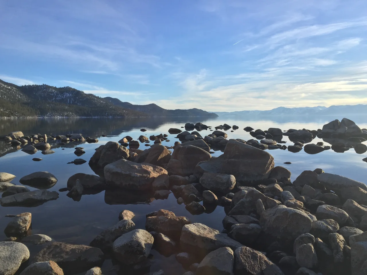
Lake Tahoe’s location, depth, and formation
Tahoe sits in the Sierra Nevada, within the ancestral homeland of the Washoe people. The main basin formed as blocks of land dropped between faults during mountain uplift. USGS places that process around 2–3 million years ago. Later glaciers reshaped parts of the surrounding landscape, especially Emerald Bay; Tahoe is not simply a hollow dug out by one glacier.
UC Davis lists Tahoe as the second-deepest lake in the United States. Its maximum depth is 1,645 ft (501 m), while the average is about 1,000 ft (305 m). The maximum describes one deepest point; the average describes the basin as a whole. Tahoe’s surface area of about 191 sq mi (495 km²) measures its footprint, not its water volume. Its depth helps explain why a mountain lake can store so much water and heat.
The Upper Truckee River is Tahoe’s largest inflowing stream. The separate Truckee River leaves at Tahoe City, passing through Truckee and Reno to Pyramid Lake. A dam regulates that outlet, although the lake itself is natural. Its great depth and volume store heat, so snowy shores do not mean the entire lake freezes in winter.
Scientists measure clarity by lowering a white Secchi disk until it disappears from view. UC Davis reported an annual average of 69.2 ft (21.1 m) for 2025 in its June 2026 report. That measures visibility through water, not lake depth, beach hygiene or a safe swimming distance.
Fine particles and plankton affect clarity. Warming, changing snowmelt, and changes in the way the lake mixes also influence its ecology. UC Davis described the 2025 clarity result as part of a plateau, rather than evidence of a sustained recovery. Clear-looking water is only one aspect of the lake’s condition.
Which shore should you visit?
Match the numbered places to the list below. Open the full-size map for labels and detail.
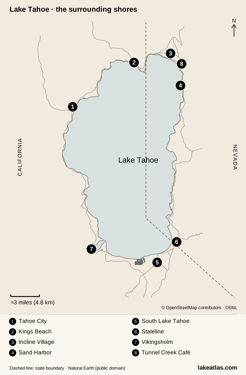
- 1Tahoe City · Truckee River outlet
- 2Kings Beach
- 3Incline Village
- 4Sand Harbor
- 5South Lake Tahoe
- 6Stateline
- 7Vikingsholm · Emerald Bay
- 8Tunnel Creek Café · near the trail’s northern end
Map design: LakeAtlas. © OpenStreetMap contributors, ODbL, retrieved October 8, 2026. State boundary: Natural Earth, public domain, retrieved October 9, 2026. Map data (GeoJSON).
Lake Tahoe’s shores and communities
| Shore or community | Places and access |
|---|---|
| Tahoe City / northwest | The Truckee River outlet and Commons Beach give a town-based lakefront stop. The park has grass, sand, picnic space and a playground. |
| Kings Beach / north | A public state recreation area with a sandy shore and pine-shaded picnic areas. Dogs are excluded from its sandy beach. |
| Incline Village / northeast | A base for the Tahoe Science Center and East Shore Trail. IVGID’s community beaches have restricted entry; lodging nearby does not automatically grant access. |
| Sand Harbor / east | State-park shoreline, coves and the southern end of the East Shore Trail. Vehicle entry has its own seasonal reservation rules. |
| South Lake Tahoe and Stateline / south | A concentration of visitor services and local transport, with access toward the southwest shore. It is a different base from the north-shore towns. |
| Emerald Bay / southwest | A glacially shaped inlet with Fannette Island and Vikingsholm. Looking from above and descending to water level are very different outings. |
California covers the western and southern lakefront, while Nevada forms the eastern side. The border is an administrative division within one basin, not a division between two lakes. For a trip, the more useful distinction is the named beach, town or trail: parking, transit and entry conditions can change between nearby destinations on the same shore.
Things to do at Lake Tahoe
Follow the East Shore Trail
The paved shared-use trail connects Incline Village and Sand Harbor over 3 miles (4.8 km) one way. An out-and-back totals 6 miles (9.7 km). Cyclists and walkers share the path, which has exposed sections with limited shade. You can turn around before the end; beach approaches do not all have the same access as the main path.
Visit Emerald Bay and Vikingsholm
The Vikingsholm path from SR 89 descends 1 mile (1.6 km): a steep return of 2 miles (3.2 km). Visitors cannot drive to the waterfront or expect a ride back up. Pets are excluded from trails, access roads and the beach; bicycles are prohibited on trails. Do not swim to Fannette Island.
Understand the lake indoors
The Tahoe Science Center at 201 Country Club Drive, Incline Village, explains the basin and its ecology through exhibits and guided visits. Tours use timed tickets; check availability for your date. It is a useful alternative when you want more context than a viewpoint supplies.
For a shorter outdoor stop, choose Commons Beach in Tahoe City or Kings Beach and stay in one place. Picnic facilities and a town lakefront can be enough for an afternoon; neither requires turning a full circuit of Tahoe into the day’s goal.
Best time to visit Lake Tahoe
Summer is the main season for lake activities and staffed shoreline facilities; winter shifts the focus toward snow and mountain recreation. Fall and spring can work for a shore-based visit, but seasonal transport, tours, and trail conditions need more attention. There is no single best season for both a beach trip and a snow trip.
Lake Tahoe by season
| Season | Conditions and activities |
|---|---|
| Summer | Lakefront walks, paddling and the broadest range of staffed facilities. Demand for popular parks and parking is high; check wind and air quality as well as sunshine. |
| Fall | A shore-focused visit can still work when weather permits, but tours, shuttles and recreation facilities withdraw on different dates. Build your plan around what is actually operating. |
| Winter | Snow changes access, road requirements and trail surfaces. A cleared town waterfront is a different proposition from a steep descent to a bay; the lake itself generally remains unfrozen. |
| Spring | A transition rather than an automatic start to summer. Snowpack and opening dates vary, especially away from maintained town areas. Check the specific road or trail. |
Seasonal status checked October 9, 2026: the East Shore Express season ended on September 12, and Vikingsholm tours finished on September 30. Check new schedules before using either service in a future itinerary.
Getting to Lake Tahoe and around the lake
Reno–Tahoe International Airport lists separate services for the north and south shores. North Lake Tahoe Express runs scheduled airport transfers requiring advance reservations. South Tahoe Airporter serves its listed south-shore stops; it is not a door-to-door service to arbitrary accommodation. Choose your base before choosing the transfer.
On the north and west shores, TART’s Mainline links Tahoma and Incline Village. Its Highway 89 service connects Tahoe City and Truckee. On the south shore, Lake Link provides on-demand rides within its service zone and connections to fixed-route transit. None of these should be treated as a single bus around the whole lake.
A car is useful when your plans span widely separated shores or trailheads. A car-free visit is more realistic when accommodation, a walkable waterfront and your main outings sit on one transit corridor. Check both the outward and return journey, including seasonal service, before committing to a walk that ends far from your base.
Beach reservations and water access
Sand Harbor uses seasonal morning vehicle reservations. As checked October 9, 2026, Nevada’s official pages disagree on whether the May season starts on the 1st or the 15th. Confirm your date in the official reservation service. Future season dates should come from the park, rather than last year’s schedule.
Entry from the East Shore Trail does not require a vehicle reservation, though park entry rules and fees still apply. Walking in along Highway 28 or being dropped at the roadside is prohibited. A place visible from a public path is not automatically a public beach: Incline Village’s IVGID beaches require authorized access.
Tahoe’s cold water and changing wind deserve attention even on a warm day. When paddling, wear a properly fitted life jacket, check local conditions and stay within your ability. The water’s color and clarity do not establish swimming conditions.
Before launching a boat, kayak, or paddleboard, check Tahoe Boat Inspections. Motorized and trailered craft require inspection; hand-launched nonmotorized craft are also subject to inspection or decontamination. Clean, drain, and dry your craft and gear to reduce the spread of invasive species. Launch facilities may have separate access rules.
A first day on the northeast shore
The northeast shore offers a clear first-day plan: walk part or all of the East Shore Trail and decide separately whether to enter Sand Harbor. This itinerary combines published distances and entry rules; it is researched guidance rather than a firsthand route report.
- Start at the northern end of the East Shore Trail near Tunnel Creek, on the Incline Village side. Arrange your arrival and return before setting off.
- Walk toward Sand Harbor and stop at viewpoints. Reaching the park and walking back totals 6 miles (9.7 km); choose an earlier turnaround if that exceeds your group’s comfortable distance.
- Carry water and sun protection. If a beach day is your main aim, arrange the park’s vehicle entry for your date instead of assuming everyone wants the long return walk.
- Book a Tahoe Science Center tour separately if you want an indoor stop in Incline Village. Arrange your return transport before the walk; the summer shuttle is not a year-round option.
Based on the south shore? Choose Emerald Bay instead: see it from above, then descend only if everyone can manage the steep return.
What did we learn about Lake Tahoe?
Tahoe’s faulted basin, deep water, and distinct shores explain both its geography and the choices a visitor faces. Its clear water remains a changing ecosystem, and its shoreline includes public parks, restricted beaches, and steep approaches. Choose a base near the outings you want, then give one shore enough time. A well-planned trail or beach visit reveals more than a day spent trying to circle the entire lake.
Sources & data notes30 references · Checked October 9, 2026
Data notes
Rounded UC Davis figures: area about 191 sq mi (495 km²), maximum depth 1,645 ft (501 m). Mean surface elevation is about 6,225 ft (1,897 m). EPA instead rounds area to 192 sq mi (497 km²); its natural-rim elevation is a different definition. Comparisons consistently use the UC Davis figures.
- Trail conversions use 1 mile = 1.609344 km and are rounded. East Shore Trail return distance is twice the published one-way length.
- The Emerald Bay park page gives conflicting ascent figures of 400 ft (122 m) and 500 ft (152 m). We describe the climb as steep.
- Clarity is a 2025 annual mean reported in June 2026, not a real-time reading. The source-check date does not mean every measurement was made that day.
- Maximum and average depths use UC Davis’s published series. NASA JPL’s older site description gives a different average-depth estimate; these are separate published estimates, not interchangeable with maximum depth. Area also varies by source: UC Davis gives 191 sq mi (495 km²) and EPA gives 192 sq mi (497 km²). LakeAtlas keeps the UC Davis figures together rather than mixing datasets.
- The seasonal Sand Harbor reservation FAQ was rechecked October 9, 2026; its conflicting May start dates remain disclosed. Use the official reservation service for the intended date.
Suggested visits are researched planning guidance, not firsthand travel reports.
References
- UC Davis — Tahoe facts
- USGS — Lake Tahoe basin
- California State Parks — Geological Gems
- NASA JPL — Tahoe site description
- UC Davis — 2025 clarity report
- UC Davis — State of the Lake
- Tahoe City PUD — Commons Beach
- California State Parks — Kings Beach
- IVGID — Incline Village beaches
- City of South Lake Tahoe — visitors
- Tahoe Fund — East Shore Trail
- Tahoe Fund — trail description
- California State Parks — Emerald Bay
- UC Davis — Tahoe Science Center
- US Forest Service — Tahoe recreation
- UC Davis — air quality and UV
- Caltrans — chain controls
- Reno–Tahoe Airport — ground transport
- North Lake Tahoe Express
- South Tahoe Airporter — FAQ
- TART — Mainline
- Lake Link — service area
- Tahoe Transportation District — 2026 summer service
- Nevada State Parks — Sand Harbor reservation FAQ
- Nevada State Parks — reservations
- Nevada State Parks — Sand Harbor
- North Lake Tahoe Fire Protection District — water safety
- Tahoe Boat Inspections — FAQ
- US EPA — About Lake Tahoe
- TART — Highway 89
Source selection & methodology. Image credits appear beside each image.