Where is Cayuga Lake?
Cayuga Lake stretches north from Ithaca in New York’s Finger Lakes region, with Tompkins, Cayuga and Seneca counties along its shores. The village of Aurora is an eastern-shore gateway; Cayuga and Union Springs are farther north, while Seneca Falls provides a base near the northwestern end. This is a long lake between communities, not a single destination centered on Ithaca.
A road close to the lake does not create continuous public access. Shoreline homes, fields and steep slopes separate parks and launch areas. Choose a named public destination on the correct side of the basin, especially when combining a beach or boat outing with wineries or waterfalls.
Match the numbered places to the list below. Open the full-size map for labels and detail.
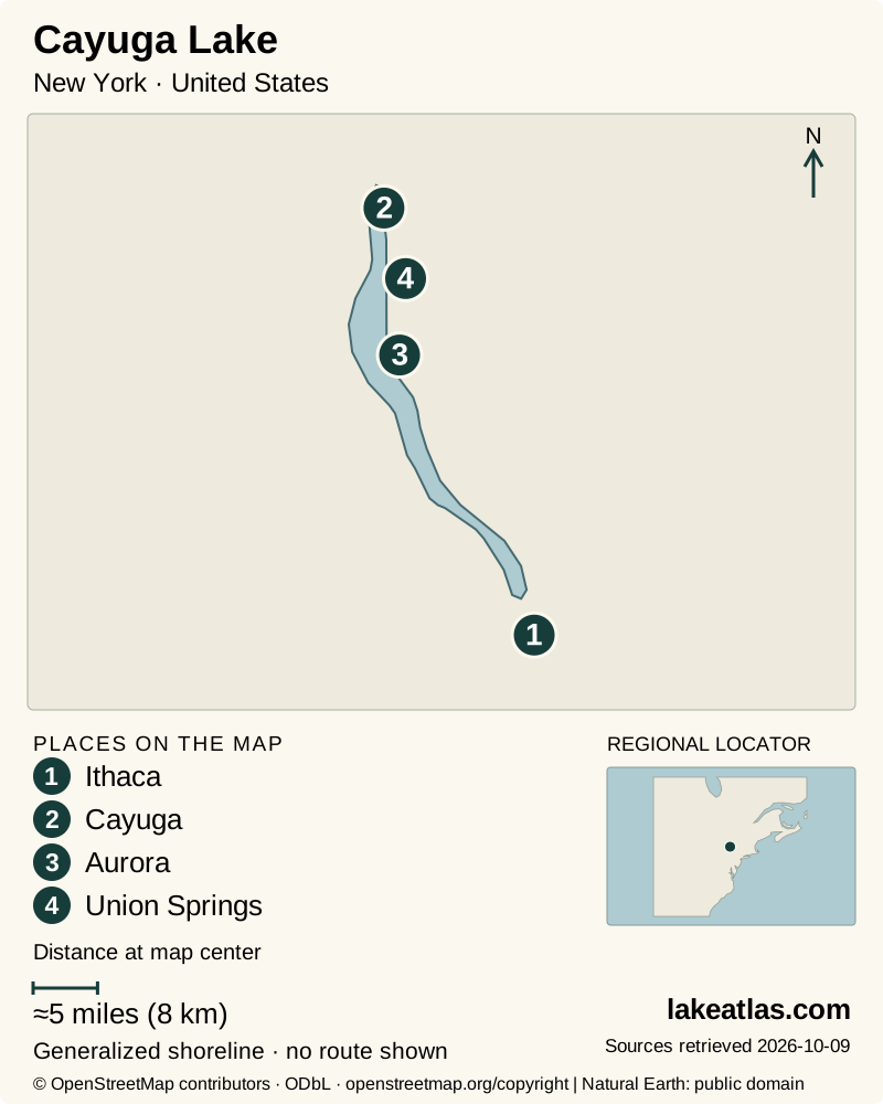
- 1Ithaca
- 2Cayuga
- 3Aurora
- 4Union Springs
Map design: LakeAtlas. Shoreline and place sources: Natural Earth (public domain) and © OpenStreetMap contributors (ODbL). Locator: Natural Earth. Retrieved October 9, 2026. Individual source links are in the downloadable GeoJSON. Map data (GeoJSON).
Cayuga’s length, depth and glacial basin
Cayuga County reports an area of 67.1 sq mi (173.8 km²), a length of 38 miles (61.2 km), a maximum depth of 435 ft (132.6 m) and a mean depth of 181 ft (55.2 m). Cayuga is the longest Finger Lake and second to Seneca in maximum depth. Rounded length figures can make the two look equal; their relative ranking is not a claim that the lakes have identical measured outlines.
The deep basin belongs to a landscape repeatedly reshaped by continental ice. Glaciers enlarged existing valleys, and retreating ice left shifting lake levels and drainage pathways. Sediment accumulated in shallower areas as tributaries entered the remaining lake. That combination helps explain the contrast between the broad southern lowland around Ithaca and the steep-sided stretches farther north.
Maximum depth should not be read as a typical swimming or launching depth. A lake-wide average also hides shallow ends, stream mouths and deep offshore water. The profile’s figures describe the basin; navigation and shore entry still depend on a specific location.
Ithaca’s waterfront and Cornell
Stewart Park is a direct public introduction to the southern shore, with lawns, picnic spaces, a playground and views along the lake. The Cayuga Waterfront Trail connects parts of the city’s waterfront; its main paths are predominantly paved, and shorter sections around Stewart Park or Cass Park work without committing to the entire network.
The city verifies accessible pathways and restrooms at both parks, with additional accessible picnic and playground facilities at Stewart Park. Those are useful concrete features; they do not turn every path or water-entry point in the wider basin into an accessible route. Check the particular facility if it is essential to a visit.
Cornell is part of an Ithaca visit but is not a substitute for lake access. Its Botanic Gardens welcome visitors, while parking follows university rules and designated lots. Combine the campus with the waterfront as two separate stops. A campus parking permit or garden opening time says nothing about access to a Cayuga Lake beach or boat launch.
Taughannock Falls and the west shore
Taughannock Falls State Park combines two distinct landscapes: Cayuga’s waterfront and an inland gorge. The waterfall drops 215 ft (66 m); the broad Gorge Trail runs about 0.75 miles (1.2 km) one way toward its base. Returning by the same trail doubles that walking distance. The rim routes climb above the gorge and should not be confused with the lower approach.
A visitor can spend time on the park’s shoreline without completing a waterfall hike. The park has a beach, camping and boating facilities, but the operator specifically says its launch is unsuitable for sailboats. Select the appropriate access and check current trail and swimming notices; a park with both a beach and a waterfall does not guarantee that either activity is available every day.
Aurora, Long Point and the northern parks
Long Point State Park lies on the eastern shore south of Aurora. Its boat launch, fishing access, picnic areas and trails make it a useful alternative to the Ithaca end. The state lists accessible fishing among its facilities, while the shore-entry route and trail gradients require separate checks. It is a boating-and-park destination rather than a replacement for every service in a lakeside town.
Near the northwestern end, Cayuga Lake State Park adds camping, a boat launch and a designated swimming beach. The beach operates seasonally and swimming depends on lifeguard coverage and water quality. Its setting can suit a north-lake stay, but the trip back to Ithaca is a regional drive rather than a quick movement between adjacent waterfront neighborhoods.
Boating, fishing and winery visits
The lake supports both boat and shore fishing, with verified public access at locations including Stewart Park, Taughannock Falls, Long Point and Cayuga Lake State Park. A fishing opportunity does not override a site’s parking, launching or seasonal rules. Use the current New York fishing regulations for species and methods rather than applying one general lake rule.
For wine tourism, the Cayuga Lake Wine Trail brings together separate businesses with their own group limits and reservation policies. Arrange transportation and confirm the actual wineries before building a day around a map of the whole lake. A designated driver or booked service allows tasting stops without turning the trip into an unplanned shore-to-shore drive.
Seasonal access and changing water conditions
Summer offers the broadest combination of park services and supervised swimming, with fall providing opportunities for winery visits and shore walks. Swimming can be suspended even within a published season. DEC’s 2025 assessment for the mid-southern main-lake segment reports harmful algal blooms; this is evidence that conditions need checking, not a daily report for every part of Cayuga.
Check current beach notices and avoid water with suspected blooms. Wind and exposed water also matter to boaters in a long basin. In winter, some park grounds remain available while restrooms and other facilities have limited operation. Snow and ice change trail conditions, and frozen water near a shoreline does not establish safe ice across the lake.
A first visit without circling the whole lake
For an Ithaca base, start with Stewart Park and a manageable section of the waterfront trail. Add a Cornell garden visit if that interests the group, allowing for campus parking. This gives a useful city-and-lake day without promising direct shoreline access from the campus.
On another outing, choose Taughannock Falls and its adjacent lakeside park, treating the lower gorge walk as an out-and-back route. A car is useful for this and for reaching Aurora or northern parks; an Ithaca waterfront walk does not require driving around the lake. Keep the plan on one shore when possible and leave a second region for another day.
What did we learn about Cayuga Lake?
Cayuga combines a deep glacial basin with a very uneven pattern of public access. Ithaca offers an urban waterfront, Taughannock pairs the shore with a separate gorge, and eastern and northern parks open other parts of the lake. Choosing one of those settings is more useful than treating the entire shoreline as a single walkable attraction.
Sources & data notes13 references · Checked October 9, 2026
Data notes
Core measurements retain Cayuga County’s original US figures, with metric equivalents calculated before rounding. Its lake length is a rounded geographic measurement, not a driving distance.
- Core measurements retain Cayuga County’s original US figures, with metric equivalents calculated before rounding. Its lake length is a rounded geographic measurement, not a driving distance.
- The reference elevation 381 ft (116 m) is not a current gauge reading. Maximum depth, average depth and surface area describe different aspects of the basin.
- The location marker is the state-published Taughannock Falls State Park destination. The Gorge Trail distance is one way; the return is additional. Water-quality discussion identifies the date and segment of the DEC report rather than treating it as live whole-lake advice.
Suggested visits are researched planning guidance, not firsthand travel reports.
References
- Cayuga County — Cayuga Lake
- USGS — Hydrogeology of sand and gravel aquifers in the Owasco Inlet watershed, Cayuga and Tompkins Counties, New York
- NYSDEC — 2025 Lake Report: Cayuga Lake, Main Lake, Mid-South
- New York State Parks — Taughannock Falls State Park
- New York State Parks — Long Point State Park – Finger Lakes
- New York State Parks — Cayuga Lake State Park
- City of Ithaca — Stewart Park
- City of Ithaca — Stewart Park & Cass Park FAQs
- Ithaca Trails — Cayuga Waterfront Trail
- Cornell Botanic Gardens — Plan Your Visit
- Cornell University — Short-Term Parking Options
- Cayuga Lake Wine Trail — Frequently Asked Questions
- NYSDEC — Cayuga Lake Angler Survey, 2023–2024
Source selection & methodology. Image credits appear beside each image.