A lake of many communities in Guatemala’s highlands
Atitlán lies in the department of Sololá, within the Guatemalan highlands. The lake is the center of a wider protected watershed whose boundaries extend beyond the shore. Do not confuse that basin reserve’s area with the area of the water itself.
Panajachel is the main tourism distribution point identified by INGUAT, reached by road through the Sololá area. Other important communities include Santiago Atitlán, San Pedro La Laguna, San Juan La Laguna, San Marcos La Laguna and Santa Cruz La Laguna. They have distinct histories, languages and access arrangements; the same lake view does not make their day-to-day geography interchangeable.
Match the numbered places to the list below. Open the full-size map for labels and detail.
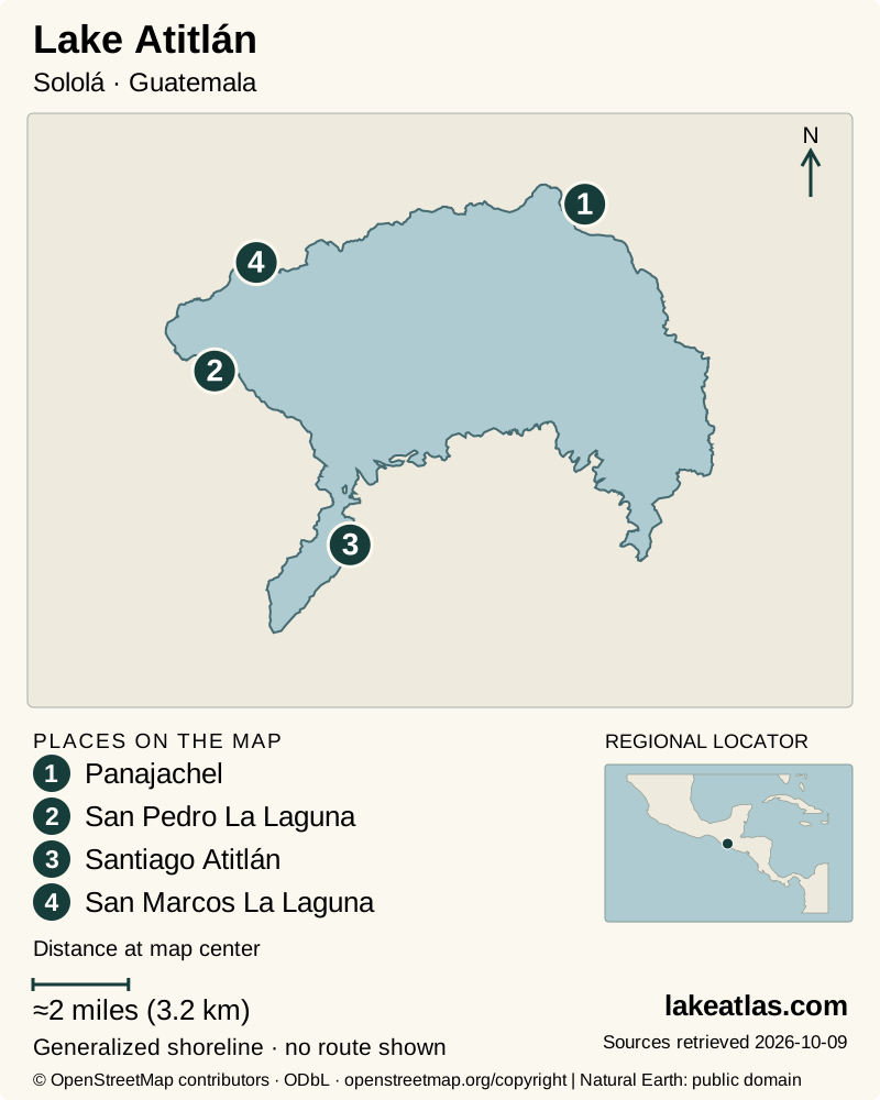
- 1Panajachel
- 2San Pedro La Laguna
- 3Santiago Atitlán
- 4San Marcos La Laguna
Map design: LakeAtlas. Shoreline and place sources: Natural Earth (public domain) and © OpenStreetMap contributors (ODbL). Locator: Natural Earth. Retrieved October 9, 2026. Individual source links are in the downloadable GeoJSON. Map data (GeoJSON).
A caldera lake below younger volcanoes
The lake occupies the northern part of the Atitlán caldera complex. Large explosive eruptions and collapse created the broad basin; the conspicuous cones of San Pedro, Tolimán and Atitlán belong to later volcanic construction around it. The water is not simply sitting in the summit crater of the volcano named Atitlán.
Smithsonian’s geological account links the latest major caldera stage to the Los Chocoyos eruption, approximately 84,000 years ago. Panajachel occupies a river delta below the caldera wall. Steep slopes and changing water levels help explain why transport and buildings concentrate on particular patches of shore.
The lake has no visible surface outlet. That hydrologic setting makes inflow, rain, evaporation and subsurface movement important to its water balance. A shoreline shown on a map should be read as a reference outline, not proof that a landing remains at exactly the same water level.
Use measured depth, not a repeated superlative
A sonar survey carried out in 2014 and published in 2018 found an area of 48.6 sq mi (125.77 km²), maximum depth of 1,075 ft (327.56 m) and mean depth of 667 ft (203.21 m). The maximum is the deepest surveyed point; the average describes the basin overall. Neither is a recommended swimming depth or an indication of conditions at a dock.
An older AMSCLAE overview repeats soundings more than 1,148 ft (350 m) without establishing the same survey basis. LakeAtlas uses the documented 2014 study consistently rather than combining incompatible figures. Its decimals preserve the authors’ published data, not a claim that today’s water level is known to that precision.
Choosing a base and visiting with cultural respect
For a first visit, Panajachel provides the clearest road-and-boat interchange. Staying there reduces the number of transfers on arrival. A stay in another town can be more closely tied to that community, but first ask how to get from its landing to the actual lodging, including luggage, slopes and any final vehicle transfer.
San Juan La Laguna offers a specific cultural thread through textile makers and local artisan organizations. One longstanding women’s organization describes its work with looms, preservation of Tz’utujil culture and support for families. Arrange a visit through the participating workshop rather than assuming every home is open to tourists.
INGUAT identifies Tz’utujil, Kaqchikel and K’iche’ communities across the wider region. These are contemporary communities, not a single interchangeable cultural attraction. Ask before photographing people or ceremonies, respect local rules at sacred places, and let residents explain how a workshop, market or religious site welcomes visitors.
Boat journeys need a named landing and a return plan
INGUAT’s Panajachel plan identifies Tzanjuyú as a public boat-transport landing. Use that named embarkation point rather than directions to the center of the lake. Confirm the destination, fare, stops and return arrangement with the operator before boarding; the plan’s older timetable is not reproduced as a current service promise.
A short line across the lake can replace a much less direct road journey, but a boat is not automatically a step-free transfer. Lake level changes affect boarding, and the walk beyond a landing can be the hardest part of arrival. Verified ramp gradients, steps and assistance arrangements were not established for this profile: contact the operator and lodging if those details affect your trip.
A car can help reach a chosen gateway, but it does not remove the need to plan boat connections or onward town access. For a first lake outing, choose one other community, allow time ashore and agree a return rather than attempting a rapid circuit of many towns.
Scenery and water quality answer different questions
AMSCLAE monitors water throughout the lake using physical and chemical measurements, laboratory samples and clarity observations. The monitoring includes nutrients and bacterial indicators as well as oxygen and temperature. A clear-looking surface or a photograph cannot substitute for location-specific public-health information.
Consult current local notices before swimming or arranging an activity that depends on water conditions. The dated reports in the basin authority’s studies collection are evidence of monitoring, not an assurance that every shore is suitable on every day. Keep wastewater and litter out of the lake and follow a guide’s or land manager’s instructions around sensitive shore habitat.
Rainy-season planning and wind on the lake
Guatemala’s broad seasonal pattern is a rainy period from May through October and a drier period from November through April. Those categories help plan clothing and flexibility; they do not guarantee rain at a set hour or calm water during the dry season. Highland weather and the lake’s steep setting still require a local forecast.
INSIVUMEH has issued specific strong-wind cautions for boats on Atitlán, including in February 2026. That is evidence that consequential wind is not confined to rainy months. Check the current forecast and the operator’s judgment on the day, and leave time in the itinerary for a crossing to be delayed or changed.
A manageable first visit
Begin in Panajachel to understand the shore and confirm a boat connection. Choose one community for an arranged cultural visit or time in town, with a return established before departure. If boating conditions are poor, keep the day on the shore where you are staying rather than trying to force the crossing.
Volcano hikes and high viewpoints are separate outings with their own trail, guide and weather requirements. They should not be added casually to a day already dependent on boat transfers. The lake’s basin and communities provide a substantial introduction without requiring a summit.
What did we learn about Lake Atitlán?
Atitlán’s depth and steep caldera setting explain both its remarkable landscape and its fragmented access. The lake connects distinct Maya communities, but visiting them well requires attention to the landing, onward walk and boat return. Use the documented bathymetry for scale, current conditions for water activities, and local voices for the cultural experience.
Sources & data notes10 references · Checked October 9, 2026
Data notes
Area and depth use the 2014 sonar survey published by Reyes Morales, Ujpan and Valiente in 2018. They are reference measurements, not a 2026 lake-level survey. The older AMSCLAE depth claim is not mixed into the 2014 series. Basin-reserve area is not lake surface area.
- Area and depth use the 2014 sonar survey published by Reyes Morales, Ujpan and Valiente in 2018. They are reference measurements, not a 2026 lake-level survey.
- The older AMSCLAE depth claim is not mixed into the 2014 series. Basin-reserve area is not lake surface area.
- Tzanjuyú’s public-landing role is documented in the 2020–2023 municipal tourism plan; present timetables, fares, ramps and boarding assistance were not independently verified.
- Weather alerts cited establish a planning risk, not current weather. No current swimming suitability or lake-wide sanitation assurance is claimed.
- The world-map marker is a representative interior point calculated from the credited map shoreline. It is a location reference, not a public access destination.
Suggested visits are researched planning guidance, not firsthand travel reports.
References
- Reyes Morales, Ujpan and Valiente — Batimetría y análisis morfométrico del lago de Atitlán (Guatemala)
- Smithsonian Global Volcanism Program — Atitlán
- INGUAT — Guía de Viaje por las Áreas Protegidas de Guatemala, second edition
- INGUAT — Plan de Desarrollo Turístico del Municipio de Panajachel 2020–2023
- AMSCLAE — Monitoreo Limnológico
- CONRED — Temporada de Huracanes y Lluvias
- INSIVUMEH — Pronóstico Basado en Impactos, February3–6,2026
- San Juan La Laguna artisans — Quiénes somos
- AMSCLAE — Lago de Atitlán
- AMSCLAE — Estudios e Informes
Source selection & methodology. Image credits appear beside each image.