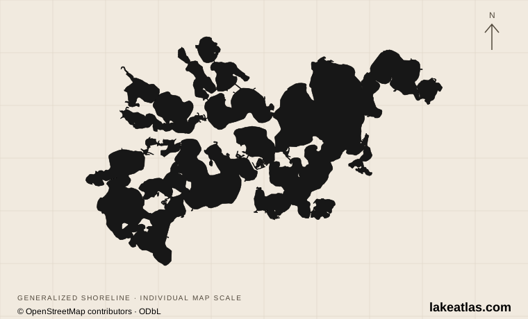
A lake of bays west of Minneapolis
Lake Minnetonka spreads through the western Twin Cities area of Minnesota, mainly in Hennepin County and extending into Carver County. It is a connected network of basins, channels, peninsulas and islands rather than a single broad oval. Wayzata on the eastern side, Excelsior on the southeast and Minnetrista near the western waters are useful gateways, but they lead to different parts of the lake.
A shore address matters more here than a lake-wide label. A hotel in one community, a launch in another and a boat rental elsewhere can add several separate journeys to a day. Pick a public waterfront or the bay you intend to use first; then choose accommodation and transport around that point.
Match the numbered places to the list below. Open the full-size map for labels and detail.
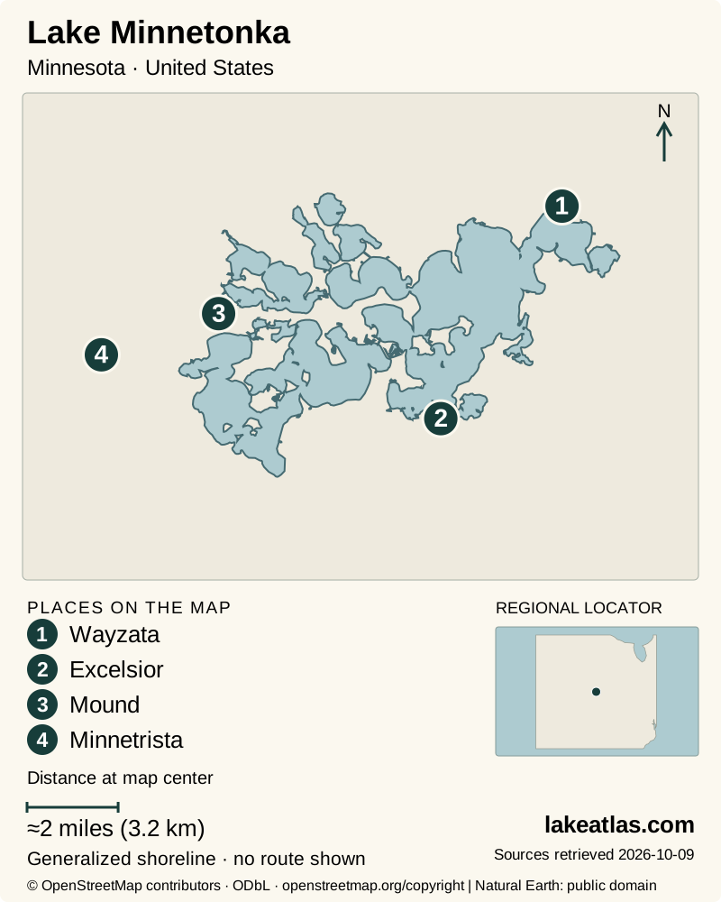
- 1Wayzata
- 2Excelsior
- 3Mound
- 4Minnetrista
Map design: LakeAtlas. Shoreline and place sources: Natural Earth (public domain) and © OpenStreetMap contributors (ODbL). Locator: Natural Earth. Retrieved October 9, 2026. Individual source links are in the downloadable GeoJSON. Map data (GeoJSON).
Why Minnetonka has so many bays
Glacial ice buried in an older river-valley landscape later melted, allowing the overlying sediment to collapse. Nearby depressions joined into a composite kettle lake. That origin helps explain why land and water interlock so tightly, and why adjacent basins can differ in depth, bottom material and ecological conditions.
For consistent comparison, LakeAtlas uses the DNR statewide inventory area of 21.9 sq mi (56.7 km²) and maximum depth of 113 ft (34.4 m). Other official summaries differ: Orono’s lake-resources page gives 101 ft (30.8 m) in Crystal Bay, while park and district descriptions round the total area differently. The source basis is stated instead of averaging incompatible figures.
A maximum depth describes one deep place, not the typical depth of every bay. Similarly, shoreline length depends on how small inlets and island shores are measured. A very long shore does not mean a continuous public walking route. Water leaves at Grays Bay toward Minnehaha Creek, with the outlet managed through a dam; the basin itself is natural.
Wayzata, Excelsior and the western park
Wayzata’s Panoway Lakewalk follows the downtown shore of Wayzata Bay. The city records completion of its 0.23 miles (0.37 km) boardwalk in June 2024. It offers a lake-facing walk beside the town rather than a route around the whole lake; later proposed park improvements should not be confused with facilities already open.
Excelsior Commons brings a different set of public uses together: shore views, picnic space, beaches, a bathhouse and docks used by excursion boats. It is a practical place to experience the lake without owning a boat. Swimming stays within the marked area, and the city reports no lifeguards. Check the current beach notice, including algae advisories, before water entry.
Lake Minnetonka Regional Park in Minnetrista provides a public boat launch, shore fishing, an accessible fishing pier, picnic facilities and trails. Its large swimming attraction is a separate filtered, chlorinated pond, not an enclosed section of Lake Minnetonka. That distinction matters when choosing between a managed family swimming facility and swimming in the lake itself.
Boating through a connected lake
Boating routes are shaped by channels and narrow passages. A direct line between two map points may cross a peninsula, a bridge or water outside the intended navigation route. Use current lake-navigation information, obey markers and allow time to pass slowly through constricted areas rather than estimating a trip from straight-line distance.
The Lake Minnetonka Conservation District maintains special slow/no-wake rules for channels, shore zones and selected bays. Rules can also change with high water. Its current wake page should take precedence over an old printed map or a cached summary; some older documents still show different distances. The lake’s heavy recreational use also means waiting at popular ramps can be part of a summer outing.
At Lake Minnetonka Regional Park, a trailer-parking pass is required for launch users. Trailer parking is up the hill from the ramp, while the fishing pier has limited nearby parking. Those are different access arrangements: an accessible pier does not establish that every launch transfer or every trail is step free.
What changes through the year
Summer supports the widest range of swimming, excursions and boating, with the most pressure on ramps and channels. The regional park’s swim pond has its own pass and operating season. Excelsior’s beach also operates seasonally; check current notices rather than assuming that a warm autumn day extends summer services.
Spring and fall can suit shoreline walks and fishing, but weather and operating schedules still control water-based plans. In winter the same channels and basin connections that make the lake interesting create variable ice conditions. Minnesota DNR does not measure or certify safe ice across the lake. A report from one bay should not be treated as permission to cross the next one.
Choose one shore for a first visit
A car is useful for a launch-centered trip or for moving between lakeside communities. For a simple first day, choose a single waterfront: the Wayzata Lakewalk for a town-and-lake walk, Excelsior Commons for a park and possible cruise, or the regional park for a planned launch or swim-pond visit. These are complete alternatives, not stops that must all fit into one circuit.
Visitors who need verified mobility features have a particularly clear option at the regional park’s swim pond: the operator lists concrete paths, an accessible water-entry ramp and beach wheelchairs. Those features concern the pond, while the accessible fishing pier concerns the lake. Confirm the exact facility and seasonal equipment before traveling.
What did we learn about Lake Minnetonka?
Minnetonka is best understood bay by bay. Its glacially linked basins explain the complex shape, but public parks and navigation rules determine how visitors actually use the water. A single well-chosen shore can deliver a satisfying day without mistaking the whole lake for one open, uniform recreation area.
Sources & data notes13 references · Checked October 9, 2026
Data notes
Comparison facts use the DNR statewide inventory: 21.9 sq mi (56.7 km²) and 113 ft (34.4 m) maximum depth. Original source acreage is retained before conversion.
- Comparison facts use the DNR statewide inventory: 21.9 sq mi (56.7 km²) and 113 ft (34.4 m) maximum depth. Original source acreage is retained before conversion.
- Other official sources give different areas and depths; Orono lists 101 ft (30.8 m) in Crystal Bay. These figures have not been reconciled to a common survey date or basin definition.
- A whole-lake maximum depth does not describe individual bays. No harmonized shoreline-length or mean-depth statistic is presented.
- Regional-park swim-pond accessibility is explicitly separate from natural-lake access. Current wake restrictions should be checked on the district page, since older official summaries differ.
- The world-map marker is a representative interior point calculated from the credited map shoreline. It is a location reference, not a public access destination.
Suggested visits are researched planning guidance, not firsthand travel reports.
References
- Minnesota DNR — Lake Minnetonka
- Minnesota DNR — Lakes, rivers, and wetlands facts
- Geological Society of Minnesota / Minnesota Geological Survey — Geology of Lake Minnetonka
- Three Rivers Park District — Lake Minnetonka Regional Park
- Three Rivers Park District — Lake Minnetonka Swim Pond
- City of Excelsior — The Commons and Port of Excelsior
- City of Excelsior — Beaches
- City of Wayzata — Panoway
- Lake Minnetonka Conservation District — Wake Rules
- City of Orono — Lake User Resources
- Minnesota DNR — Ice safety
- Minnehaha Creek Watershed District — Gray’s Bay Dam Operations
- Lake Minnetonka Conservation District — Lakeshore Owners
Source selection & methodology. Image credits appear beside each image.